本教程主要讲述怎样使用ArcGIS软件来定义shapefile坐标系,具体的操作步骤等,同时也列出定义shapefile坐标系的主要的机种方法等。
ArcGIS中shapefile坐标系如何定义――工具/原料ArcGIS软件电脑ArcGIS中shapefile坐标系如何定义―― 通过选择现有坐标系定义shapefile的坐标系
在 ArcCatalog 中,单击要为其定义坐标系的 Shapefile。
单击文件菜单,然后单击属性。
单击 XY 坐标系选项卡。
浏览到要使用的坐标系,然后选择该坐标系。坐标系的参数将在当前坐标系文本框中列出。可以双击坐标系获取详细信息。
单击 Shapefile 属性对话框上的确定。
ArcGIS中shapefile坐标系如何定义――通过导入坐标系定义shapefile的坐标系ArcGIS中shapefile坐标系如何定义 1、
在ArcCatalog 中,单击要为其定义坐标系的shapefile。
ArcGIS中shapefile坐标系如何定义 2、
单击文件菜单,然后单击属性。
ArcGIS中shapefile坐标系如何定义 3、
单击 XY 坐标系选项卡。
ArcGIS中shapefile坐标系如何定义 4、
单击导入。
ArcGIS中shapefile坐标系如何定义 5、
浏览到要复制其坐标系参数的数据源。例如,可以从 coverage、栅格或地理数据库中的要素数据集和要素类获取坐标系信息。
ArcGIS中shapefile坐标系如何定义 6、
单击数据源。
ArcGIS中shapefile坐标系如何定义 7、
单击添加。坐标系的参数将列在详细信息框中。
ArcGIS中shapefile坐标系如何定义 8、
单击 Shapefile 属性对话框上的确定。
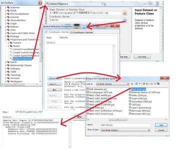
ArcGIS中shapefile坐标系如何定义――通过指定新地理坐标系定义shapefile的坐标系
ArcGIS中shapefile坐标系如何定义 1、
在ArcCatalog中,单击要为其定义坐标系的shapefile。
ArcGIS中shapefile坐标系如何定义 2、
单击文件菜单,然后单击属性。
ArcGIS中shapefile坐标系如何定义 3、
单击 XY 坐标系选项卡。
ArcGIS中shapefile坐标系如何定义 4、
单击新建,然后单击地理。
ArcGIS中shapefile坐标系如何定义 5、
输入新地理坐标系的名称。
ArcGIS中shapefile坐标系如何定义 6、
输入合适的长半轴和短半轴或反扁率值,并输入自定义旋转椭球体和基准面的名称。也可单击基准面或旋转椭球体下拉箭头,然后单击预定义基准面或旋转椭球体。
ArcGIS中shapefile坐标系如何定义 7、
输入合适的每单位弧度并输入自定义单位的名称。也可单击角度单位下拉箭头,然后单击预定义测量单位。
ArcGIS中shapefile坐标系如何定义 8、
输入用于定义本初子午线的适当的度、分和秒并输入该经线的名称。也可单击本初子午线下拉箭头,然后单击预定义经线。
ArcGIS中shapefile坐标系如何定义 9、
单击确定。
ArcGIS中shapefile坐标系如何定义 10、
单击 Shapefile 属性对话框上的确定。
ArcGIS中shapefile坐标系如何定义――通过指定新投影坐标系定义shapefile的坐标系ArcGIS中shapefile坐标系如何定义 1、
在 ArcCatalog 中,单击要为其定义坐标系的 shapefile。
ArcGIS中shapefile坐标系如何定义 2、
单击文件菜单,然后单击属性。
ArcGIS中shapefile坐标系如何定义 3、
单击 XY 坐标系选项卡。
ArcGIS中shapefile坐标系如何定义 4、
单击新建,然后单击投影。
ArcGIS中shapefile坐标系如何定义 5、
输入自定义坐标系的名称。
ArcGIS中shapefile坐标系如何定义 6、
单击投影名称下拉箭头,然后单击其中一个所支持的投影。
ArcGIS中shapefile坐标系如何定义 7、
为该投影输入合适的参数值。
ArcGIS中shapefile坐标系如何定义 8、
单击线性单位下拉箭头,然后单击预定义测量单位。或者,单击下拉列表中的“<自定义>”,输入合适的每单位米数,然后输入自定义单位的名称。
ArcGIS中shapefile坐标系如何定义 9、
通过选择预定义地理坐标系或定义新地理坐标系来定义投影的基准面。此后,可根据需要修改地理坐标系的参数。
ArcGIS中shapefile坐标系如何定义 10、
单击确定。
ArcGIS中shapefile坐标系如何定义 11、
单击 Shapefile 属性对话框上的确定。
ArcGIS中shapefile坐标系如何定义――通过修改坐标系的参数定义shapefile的坐标系ArcGIS中shapefile坐标系如何定义 1、
在 ArcCatalog 中,单击要为其定义坐标系的 shapefile。
ArcGIS中shapefile坐标系如何定义 2、
单击文件菜单,然后单击属性。
ArcGIS中shapefile坐标系如何定义 3、
单击 XY 坐标系选项卡。
ArcGIS中shapefile坐标系如何定义 4、
单击修改。随即出现地理坐标系属性或投影坐标系属性对话框。
ArcGIS中shapefile坐标系如何定义 5、
按照用于定义新地理坐标系或新投影坐标系的步骤更改相应的参数。
ArcGIS中shapefile坐标系如何定义 6、
单击确定。
ArcGIS中shapefile坐标系如何定义 7、
单击 Shapefile 属性对话框上的确定。
ArcGIS中shapefile坐标系如何定义――通过将坐标系保存到文件定义shapefile的坐标系ArcGIS中shapefile坐标系如何定义 1、
在ArcCatalog中,单击要为其定义坐标系的shapefile。
ArcGIS中shapefile坐标系如何定义 2、
单击文件菜单,然后单击属性。
ArcGIS中shapefile坐标系如何定义 3、
单击 XY 坐标系选项卡。
ArcGIS中shapefile坐标系如何定义 4、
单击 Shapefile 属性对话框上的另存为。
ArcGIS中shapefile坐标系如何定义 5、
浏览到要放置坐标系文件的位置。例如,将其放置到网络上的共享文件夹中。
ArcGIS中shapefile坐标系如何定义 6、
输入坐标系文件名并单击保存。
ArcGIS中shapefile坐标系如何定义 7、
单击确定。该坐标系文件将出现在文件夹的“内容”列表中。